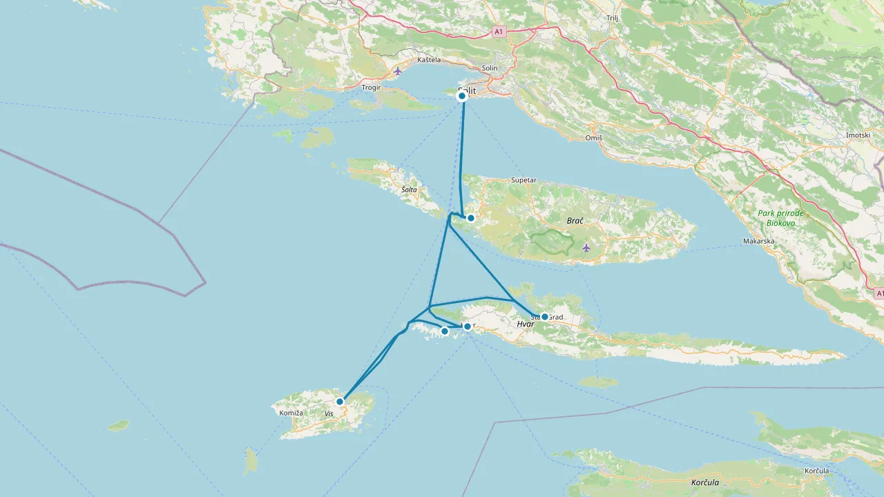
Sailing Route · Croatia
7-Day Split to Split Sailing Itinerary in Croatia
Is this route for you?
- Typical day
- 24.8 nm over 7 sailing days
- Longest day
- 45.7 nm, day 3 (09:00–16:57)
- Returns to base
- Yes — a loop from ACI Marina Split
- Nights
- 7 in a marina
- Deepest draft accepted
- 4 m — set by the shallowest stop on the route
Distances and times are sailing distances over water at 6 kn, computed from the charted route between each stop — not straight lines.
- 09:00 Sail 11.7 nm to ACI Marina Milna
- 11:17 Berth for the night, ACI Marina Milna
No prevailing wind data is available for this passage, so point of sail and sailing conditions cannot be described.
Crews motor this leg when wind conditions are unsuitable or absent, though specific patterns are not documented for this route.
ACI Marina Milna monitors VHF channel 17 and offers excellent protection from all winds once inside.
ACI Marina Milna is a marina in Milna on the island of Brac, Croatia, offering 148 berths and open all year round.
Ashore
- Zlatni rat beach near Bol
- Diocletian's Palace in Split
Provisions Grocery store in marina
Dining Restaurant in marina
If it's full, or the wind is wrong
- Uvala Livke 3.4 nm away
- 09:00 Sail 22.7 nm to Viska Luka Marina (Port Vis)
- 13:07 Berth for the night, Viska Luka Marina (Port Vis)
No prevailing wind data is available for this passage, so point of sail and sailing conditions cannot be described.
Crews motor this leg when wind conditions are unsuitable or absent, though specific motoring patterns are not documented for this route.
Viska Luka Marina monitors VHF channel 17 and offers shelter from all directions, though swell from ferry traffic occurs and the harbor is exposed during Bora and Jugo conditions.
Viska Luka Marina, also known as Port Vis, is a natural harbor on the island of Vis, Croatia, offering mooring buoys and quay berths with electricity, water, and fuel.
Provisions Supermarkets very near
Dining Large restaurant selection
Anchor nearby Anchoring not permitted; use mooring buoys
If it's full, or the wind is wrong
Anchoring not permitted; use mooring buoys
- 09:00 Sail 45.7 nm to ACI Marina Korčula
- 16:57 Berth for the night, ACI Marina Korčula
No prevailing wind data is available for this passage, so point of sail and sailing conditions cannot be described.
Crews motor this leg when wind conditions are insufficient or unfavorable for sailing, or when maneuvering into the marina's confined waters.
ACI Marina Korčula monitors VHF channel 17 and offers shelter from NW Maestral but remains exposed to SE Jugo; minimum depth is 4 meters with maximum draft accommodation of 5 meters.
ACI Marina Korcula is a 159-berth marina on Korcula island's northeast coast, beside the medieval Old Town, open all year round.
Ashore
- Korcula Old Town (medieval walls)
- St Mark's Cathedral with Tintoretto altarpiece
- Marco Polo's House
- Moreška sword dance (summer)
Provisions Studenac in Old Town; larger Konzum 10 min walk
Dining Filippi fine dining; Konoba Adio Mare for peka
Anchor nearby Vela Luka marina 30 nm west, quieter and less touristy
If it's full, or the wind is wrong
Vela Luka marina 30 nm west, quieter and less touristy
- Luka Korčula 0.6 nm away
- Port of Kuciste 2.0 nm away · anchor, no fee
- Marina Orebic 2.2 nm away · marina berth
- 09:00 Sail 38.5 nm to ACI Marina Palmižana
- 15:45 Lunch and swim, ACI Marina Palmižana
- 17:15 Sail 2.4 nm to Harbour of Hvar (Nauticki Centar Hvar)
- 17:59 Berth for the night, Harbour of Hvar (Nauticki Centar Hvar)
No prevailing wind data is available for this passage. Departure timing cannot be determined from the information provided.
Crews motor this leg when wind conditions are unsuitable or to ensure timely arrival, as the marina fills by early afternoon in July and August.
Baba Rock (43°10.1'N 16°23.8'E, Fl(2) W 10s 7m 4M) marks the entrance hazard. The southern approach via Borovac–Sv. Klement passage is shallow (under 5 m) and unlit. Call VHF 17 for berth assignment; larger vessels may moor sideways with prior notice due to pontoon reconstruction.
Baba Rock (43°10.1'N 16°23.8'E, Fl(2) W 10s 7m 4M) at entrance; tidal wave possible in strong SW–W winds; southern approach via Borovac–Sv. Klement passage is shallow (<5 m) and unlit.
ACI marina Palmizana is a seasonal marina on the island of Sv. Klement in the Pakleni Islands, offering 180 berths, protection from most winds, and a peaceful natural setting.
Provisions Grocery store on site; fuel station 2.5 nm away
Dining Restaurant on site
No prevailing wind data is available for this passage, so point of sail cannot be determined from the records provided.
Crews motor this short inter-island leg when conditions require engine use or when time is a factor between the two harbours.
Watch for Baba Rock (Fl(2) W 10s 7m 4M) at the entrance to Palmižana on departure. Harbour of Hvar offers good shelter except in strong S and SW winds; contact the marina on VHF 09 with minimum depth 3 m and maximum draft 5 m.
Harbour of Hvar (Nauticki Centar Hvar) is a marina in Hvar town on Hvar Island, Croatia, offering about 20 quay berths and mooring buoys, with depths of 3-4 metres.
Ashore
- Hvar Fortress
- Franciscan Monastery
- Pakleni Islands
- Hvar Public Theatre
Provisions Shops and market in town centre, short walk from quay
Dining Numerous restaurants and cafes along the Riva and in town
Anchor nearby Mooring buoys off W quay in depths over 3 m; anchoring prohibited in bay
If it's full, or the wind is wrong
Mooring buoys off W quay in depths over 3 m; anchoring prohibited in bay
- 09:00 Sail 15.5 nm to Stari Grad
- 11:55 Berth for the night, Stari Grad
No prevailing wind data is available for this passage, so point of sail and sailing conditions cannot be described.
Crews motor this leg when wind conditions are unsuitable or absent, though specific reasons are not documented for this route.
Stari Grad marina monitors VHF channel 17, maintains a minimum depth of 2 metres, and offers shelter from northerly through south-westerly directions.
Stari Grad is a town harbour on Hvar Island, Croatia, offering 60 mooring berths with water and electricity in depths of 2.0-5.0 metres, protected from all winds except west and northwest.
Provisions Tommy hypermarket 100 m south of ferry quay
Dining Eremitazh upscale; Antika quaint; local konobas
Anchor nearby Zavala bay 1.4 nmi with buoys and taxi boat
If it's full, or the wind is wrong
Zavala bay 1.4 nmi with buoys and taxi boat
- 09:00 Sail 23.0 nm to Maslinica
- 13:10 Berth for the night, Maslinica
No prevailing wind data is available for this passage, so point of sail cannot be determined from the records provided.
Crews motor this leg when wind conditions are unsuitable or absent. The shallow minimum depth of 2 m in Maslinica may require attention from deeper-draft vessels.
Approach Maslinica with care: shallow channels between Polebrnjak and Saskinja have minimum depth 2.8 m, Hrid Kamičić rock lies SSW of Balkun island, and shallows extend SW of the harbour entrance. Monitor VHF channel 17.
Strong W wind can bring heavy swell into harbour,Bora and SE wind may cause wave formation,Shallow channels between Polebrnjak and Saskinja (min depth 2.8 m),Hrid Kamičić rock SSW of Balkun island,Shallows SW of harbour entrance
Maslinica offers a 50-berth boutique marina with a heritage castle hotel on Solta’s west coast, accommodating yachts up to 80 m and 12 m draft, ideal for central Dalmatian sailing.
Provisions Small shops and bakeries in Maslinica village; market in Grohote.
Dining Restaurant Sismis at castle; local konobas in village.
Anchor nearby Anchor northwest between nearby islands; depths 4-8 m sand/mud.
If it's full, or the wind is wrong
Anchor northwest between nearby islands; depths 4-8 m sand/mud.
- Martinis Marchi Marina 0.0 nm away · marina berth
- 09:00 Sail 13.8 nm to ACI Marina Split
- 11:38 Berth for the night, ACI Marina Split
No prevailing wind data exists for this passage, so point of sail cannot be determined from available records.
Crews motor when conditions require engine use or when departing Maslinica if strong W wind brings heavy swell into the harbour, making sail handling difficult.
Departing Maslinica, avoid Hrid Kamičić rock SSW of Balkun island and shallows SW of the harbour entrance; channels between Polebrnjak and Saskinja shoal to 2.8 m minimum depth. ACI Marina Split monitors VHF 17 and offers shelter from S.
ACI Marina Split is a well-sheltered marina in Uvala Baluni, Split, with 318 berths, open year-round, offering great views of Diocletian's Palace and convenient access to the city.
Ashore
- Diocletian's Palace (UNESCO)
- Split Riva promenade
- Cathedral of St. Domnius
Provisions Grocery store in marina; ATM on site
Dining Restaurant in marina; Split Old Town nearby
Anchor nearby Anchoring forbidden in port except emergencies
If it's full, or the wind is wrong
Anchoring forbidden in port except emergencies
- Lučica Slatine 4.5 nm away · marina berth
- Lučica Spinut 4.6 nm away · marina berth
- Marina Lav 5.0 nm away · marina berth
Explore next
Destination guide
Croatia
Croatia's Adriatic coast is a sailor's playground of islands, hidden bays, and historic ports. Choose your base and set sail.