Navigating the open seas has never been easier with the advent of modern technology.
Today, we have many sailing and yachting apps at our disposal, designed to enhance our maritime experiences.
These apps offer a wide range of features, from sophisticated navigation systems and detailed marine charts to weather forecasting and cruising guides. But with so many options available, how do you choose the best one for your needs?
To help you navigate these waters, we have ranked and described the top 10 sailing and yachting apps based on their ratings and reviews obtained from the Google Play Store.
Whether you’re a novice sailor looking for guidance or an experienced yachtsman seeking advanced features, this article will guide you to the app that best suits your needs. So, let’s set sail and explore these apps!

Navionics® Boating is a comprehensive marine navigation app developed by Garmin Italy Technologies srl. This app is designed to provide accurate and detailed nautical charts, making it an essential tool for sailors, fishermen, divers, and boaters of all kinds.
The app offers a wide range of features including the ability to track your journey, mark waypoints, and capture geo-tagged photos. It also provides real-time weather data and tide & current predictions, ensuring you have all the information you need for a safe and enjoyable journey.
One of the standout features of Navionics® Boating is its SonarChart™, an HD bathymetry map that reflects ever-changing conditions. This feature allows users to contribute to the app’s database by sharing their sonar logs, helping to enhance chart details that are beneficial to the entire community.
Navionics® Boating also supports synchronization across multiple devices, ensuring you have access to your data wherever you are. The app is compatible with a variety of chart plotter brands, making it a versatile choice for those in need of reliable marine navigation software.
Whether you’re planning a fishing trip, a leisurely sail, or a diving expedition, Navionics® Boating provides a wealth of resources to ensure you’re prepared for whatever comes your way.
Sail Expert: Sailing App by Poterion

Sail Expert: Sailing App, developed by Poterion, is a comprehensive tool designed to enhance the sailing experience. Often referred to as the Swiss knife for sailors, this app offers a wide range of features that support navigation, regattas, and various boat maintenance logs.
The app’s sensors are used to fill the logs with data such as location, COG (Course Over Ground), SOG (Speed Over Ground), temperature, and pressure. If a WiFi NMEA (National Marine Electronics Association) provider is available, boat sensors are used instead, ensuring accurate and real-time data.
Sail Expert also supports a Wear OS watch companion app, allowing sailors to display instruments on their smartwatch. This feature brings essential data right to your wrist, making it easily accessible during your sailing adventures.
The navigation feature of the app provides alerts for off-course or target course, calculates the remaining distance, and estimates the arrival time. It also helps sailors plan passages using a graph of distance and time, and assists in crossing the start line at the optimal speed during regattas.
The app supports easy check-in and check-out of boat transfers, allowing sailors to prepare for trips in advance. Trips or parts of them can be exported directly from the app to CSV, GPX, and PDF formats. The data logged in the app can be synchronized with the Sail Expert website as needed.
While at anchor, the app monitors your position and sounds an alarm if you drift outside the set area. This area can be configured as a position and radius, or a series of points (polygon). A second device can be set up to remotely monitor the anchor alarm, providing an extra layer of safety.
Sail Expert: Sailing App does not require an internet connection or registration of basic functions, making it a reliable tool for sailors in all conditions. The developers encourage users to submit a report if the application malfunctions or crashes, ensuring continuous improvement and user satisfaction.
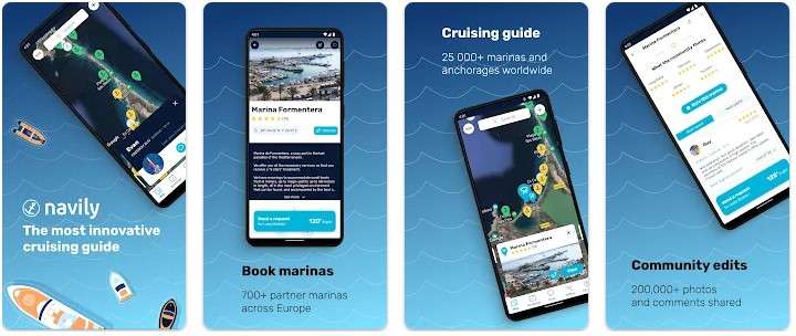
Navily is a popular cruising guide app with over 500,000 users worldwide. It serves as an ideal companion for all your boat trips, providing a comprehensive guide with over 25,000 marinas and anchorages. The app is enriched with 200,000 photos and comments from the community, offering real-time insights and experiences from fellow boaters.
One of the key features of Navily is its easy booking system. With over 700 partner marinas across Europe, Navily allows you to secure a berth in just a few clicks. The app partners with marinas to provide information updated in real time by the marinas themselves, including a full price list, operating hours, events, tourist attractions, services, and facilities.
Navily also features an in-app chat with users and marinas, fostering a sense of community among its users. It also includes real-time warnings on anchorages and an Emergency SOS feature, ensuring safety and assistance when you need it.
The Navily Premium offers even more functionalities, including weather forecasts, distance calculation and automatic itineraries, offline mode, advanced map filters, and an ad-free experience.
The app also encourages users to share their own experiences, contributing to the community by sharing photos, reviews, and helping to build the most innovative cruising guide. Navily is available in multiple languages including French, Spanish, German, and Italian.
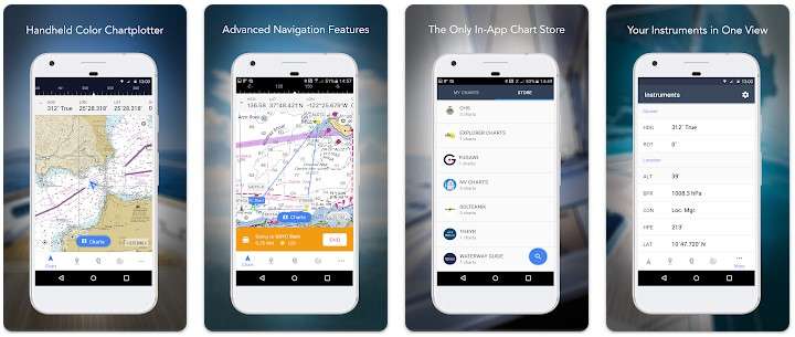
iNavX: Marine Navigation, developed by NavX Studios, is a sophisticated handheld chartplotter and marine navigation application. It’s recognized as the world’s #1 handheld Chartplotter, providing access to marine charts, maps, weather, AIS (Automatic Identification System), and more.
The app offers complete worldwide chart coverage from multiple providers, including iNavX Professional+ Charts, Blue Latitude, Explorer, Theyr Weather, Waterway Guide, and more. This makes iNavX a versatile tool for sailors, boaters, and anglers alike.
For sailors, iNavX allows planning sailing routes with waypoint and route management. It provides proactive sail management with GRIB weather forecasts and AIS overlays, integrating with onboard systems. Sailors can also geotag photos to remember great sailing locations.
Boaters can stay updated on boating conditions with forecasts that include currents, winds, and swells. The app integrates with nautical instruments, allowing boaters to manage their equipment effectively. Boaters can also save and share great boating routes with the track log.
Anglers can discover new fishing spots by scouting out holes and inlets. They can identify the best fishing conditions and save their best fishing spots with unlimited markers.
iNavX supports NMEA data over TCP/IP using WiFi and integrates with external GPS, AIS receivers, and transponders. It also connects with nautical instruments such as Depth, Speed, Wind, Engine, Batteries, etc.
The app includes an essential toolkit with a GRIB weather forecast, tides/currents, an anchor alarm, AIS integration, and a port/navaid search. Users can also print detailed charts to use in combination with the app.
iNavX is compatible with various marine technology providers, including C-MAP, Theyr Weather, Waterway Guide, AIS, Brookhouse, DigitalYacht, ShipModul, vYacht, Vesper Marine, NMEA 2000, Chetco, and more. It offers a new chart store where users can purchase all their favorite charts with subscriptions varying by chart and provider.
The app has been praised by Practical Sailor, Sail Magazine, and iMarineApps for its comprehensive features and user-friendly interface.

C-MAP – Marine Charts, developed by Navico Norway AS, is a marine chart plotter application that provides high-quality sea charts, navigation, traffic information, and weather data to assist in planning your next water trip.
The app offers downloadable offline charts that ensure safety and stress-free enjoyment during cruising, fishing, and sailing. You can adjust the maps by saving routes, waypoints, and tracks, all of which can be accessed offline. The app also allows you to remember that special day or share your trip with friends and family, including reviews and photos.
With C-MAP, you can:
- Download or stream the latest offline sea charts for free
- Find the optimal route to your favorite places using automatic routing
- Navigate with your personal offline chart and maintain access to saved routes, locations, and tracks as if you were online
- Refer to AIS data: check the boats around you within a radius of 100 km, and their position, speed, and course
- Switch between day, night, and bright modes
- Obtain weather information
- Find relevant information about marinas, ports, beaches, shops, etc.
- Personalize your own map: highlight areas of the map based on the size of your boat, use your favorite measurement units, and create routes and tracks for locations
- Share locations, routes, tracks, reviews, photos, etc., to help others find the best places
- Save places you want to visit and access them later from any computer or device
The C-MAP app is continuously updated to ensure the best experience and provide the latest maps and features. The maps are available online for free. You can also purchase a subscription for one of the new 70 regions, download charts to your mobile device, save data, and enjoy maps even in remote areas without a connection.
The app has been praised for its comprehensive features and user-friendly interface, making it a reliable tool for sailors and boaters alike.
Windy.com – Weather Forecast

Windy.com, also known as Windyty, is an exceptional tool for visualizing weather forecasts. This fast, intuitive, detailed, and highly accurate weather app has earned the trust of professional pilots, paragliders, skydivers, kite surfers, surfers, boaters, fishermen, storm chasers, weather geeks, and even government and military officials, rescue teams, and more.
Whether you’re tracking tropical storms or potential bad weather, planning a trip, pursuing your favorite outdoor sports, or just need to know if it’s going to rain over the weekend, Windy provides the latest weather forecasts for your area.
What sets Windy apart from other weather apps is its ability to provide higher quality information than most professional features of other apps, all while being completely free and without ads. The powerful, smooth, and fluid display makes weather forecasting truly enjoyable!
Windy offers all leading weather forecast models, including global ECMWF and GFS, as well as local NEMS, AROME, and ICON (for Europe), NAM (for America). You can access over 40 weather maps, including wind, rain, temperature, pressure, swell, and even the CAPE index.
The app also features global satellite composite images created from NOAA, EUMETSAT, and Himawari. The images are updated every 5-15 minutes depending on the area. Doppler radar covers most of Europe, America, Asia, and Australia.
You can display observed wind and temperature, weather forecasts, airports worldwide, over 1500 paragliding spots, and nearby webcams on the map. The app is fully customizable, allowing you to add your favorite weather maps to the quick menu, customize the color palette of the layers, and access detailed options in the settings.
Windy offers features and data sources such as:
- All leading weather forecast models: ECMWF, GFS by NOAA
- Several local weather models NEMS, ICON, Arome, NAM
- High-resolution satellite composite images
- Comparison of forecast models
- Over 40 global weather maps
- Weather radar for many places in the world
- 16 altitude levels from the surface up to 13.5km/FL450
- Metric or imperial units
- Detailed weather forecast for any location (temperature, rain and snow accumulation, wind speed, gusts, wind direction)
- Detailed Airgram and Meteogram
- Meteogram: temperature and dew point, wind speed and gusts, pressure, precipitation, cloud cover for each altitude
- Altitude and time zone information, sunrise and sunset time for any location
- Customizable list of favorite spots (with the option to create email alerts for future weather conditions)
- Nearby weather observations (real-time observed weather – reported wind direction, wind speed, temperature)
- Searchable over 50,000 airports by ICAO and IATA, including runway information, decoded and raw METAR, TAF, NOTAMs
- Over 1500 paragliding spots
- Detailed wind and wave forecasts for kite and surfing spots
- Webcams
- Tide forecast
- Topographic maps by Mapy.cz and satellite images by Here Maps
- English + 40 other languages
PredictWind – Marine Forecasts

PredictWind – Marine Forecasts, developed by PredictWind Limited, is a powerful tool that provides accurate weather forecasts and a suite of marine tools to ensure safety and efficiency on the water. With access to the world’s top ranking forecast models, including ECMWF, SPIRE, UKMO, GFS, and more, PredictWind offers reliable and accurate weather data. The app’s very own PWG & PWE models offer incredible accuracy and a record-breaking 1km resolution.
The app allows you to view high-resolution maps for wind, gust, CAPE, wave, rain, cloud, pressure, air temperature, sea temperature, ocean data, and solunar. In addition to forecasts, PredictWind provides a suite of powerful marine tools. The Weather Routing feature takes your start and end points then calculates your route factoring in tides, currents, wind and wave data, depth, and your boat’s unique dimensions to give you the best route for comfort or speed. Departure Planning quickly summarises the weather conditions you’ll encounter along your route if leaving on day 1, 2, 3, or 4, helping you select the perfect departure date.
Additional features include Daily Briefing, high-resolution forecast maps with animated streamlines, wind barbs or arrows, detailed analysis tables, comparison graphs for multiple forecasts, live observations and webcams, local knowledge about the best spots, amenities, and activities at your destination, weather alerts, ocean data, free customised GPS tracking page for your blog or website, and AIS data to view over 280,000 vessels worldwide on the AIS network.
The app is continuously updated to ensure the best experience and provide the latest maps and features. It has been praised for its comprehensive features and user-friendly interface, making it a reliable tool for sailors, boaters, and weather enthusiasts alike.
MarineTraffic – Ship Tracking

MarineTraffic – Ship Tracking is a leading ship tracking application developed by MarineTraffic. It displays near real-time positions of ships and yachts worldwide. Connected to the largest network of land-based AIS receivers, this app covers most major ports and shipping routes.
The app allows you to view vessels on the live map, search for ships, boats, and seaports, and see what’s near you. More than 100,000 vessels per day report their positions via MarineTraffic AIS. You can view live wind and 48-hour wind forecast on the map, animate the tracks of past voyages, and see the current status of ports, expected arrival times of boats and ships.
You can manage your list of vessels (“MY FLEET”), which is shared across all your devices and MarineTraffic.com. The app also allows you to view over 2.5 million photos of ships, ports, lighthouses, and more.
With ACCESSPLUS 24 (in-app purchase), you can identify and track vessels sailing beyond the range of terrestrial AIS receiving stations, using satellite tracking. The app also features an augmented reality tool that allows you to identify vessels around you at a glance. Just point your device’s camera towards the horizon and get all the information you need about the vessels in your area, such as name, flag, speed, distance, and more.
For paid subscribers of MarineTraffic, the app offers additional features such as nautical charts, advanced weather maps, advanced density maps, and SAT-AIS data.
The app is continuously updated to ensure the best experience and provide the latest maps and features. It has been praised for its comprehensive features and user-friendly interface, making it a reliable tool for sailors, boaters, and maritime professionals alike.
SailFreeGPS
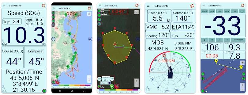
SailFreeGPS, developed by FredB, is a comprehensive sailing app that turns your smartphone or tablet into a unique navigation device. It displays your current location, course (COG), speed (SOG), maximum speed, trip distance, average speed, and a magnetic compass.
SailFreeGPS displays the history of your COG and SOG (up to 6 hours), allowing you to check the trim effects of your sail. It also filters GPS information to enhance accuracy (averaging the last set of measurements). The app allows you to share your position, COG, and SOG with friends. It also assists during Man OverBoard operations (MOB), saving the location and guiding you to it.
The app displays your track on Google Maps (up to 24 hours) and assists during regattas with a countdown timer and a start line. You can save up to 8 waypoints and activate the GOTO function using ETA (Estimated Time of Arrival). You can also save/load your track in GPX/KML files, calculate distance and bearing, and activate an anchor alarm or course alarm.
SailFreeGPS is suitable for all boats, motorboats, and sailboats. The developer, an amateur sailor who decided to create this app after an Atlantic crossing cruise, regularly adds new features to the app as time permits. For better results, don’t forget to calibrate your compass
Aqua Map – Mobile Chartplotter
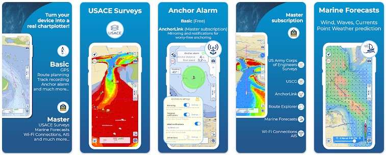
Aqua Map – Mobile Chartplotter, developed by GEC srl, is a comprehensive marine navigation app that offers a wide range of features to ensure a safe and enjoyable time on the water. The app is optimized for both smartphones and tablets and provides access to the most updated USACE surveys and USCG List of Lights.
Aqua Map offers vector and raster nautical charts for offline use, updated regularly. It also includes satellite images and a manual route planning feature. The app provides real-time information on bridges, hazards, and best fuel prices during route navigation. It also includes a basic anchor alarm and an advanced AnchorLink with mirroring and email/telegram notifications.
The app provides marine forecasts for wind, waves, currents, and worldwide weather information. It also includes over 1800+ weather buoys and tide & current predictions and simulations. Aqua Map also features a powerful search with advanced settings and a light/dark display mode.
One of the standout features of Aqua Map is the Live Sharing-Aqua Map community feature, which allows you to find new friends on the water and share your data with the community without leaving the app. The app also integrates with the “ActiveCaptain” and “Waterway Guide” communities, providing access to tens of thousands of points of interests and reviews all over the world.
Aqua Map also allows you to connect NMEA devices through WiFi and use instrument and AIS data all across the app, including navigation and anchor watch. It also displays AIS targets on the chart with automatic collision detection.
The premium version of the app, Aqua Map Master, offers additional features such as marine forecasts, AnchorLink with mirroring and telegram/email notifications, and a Route Explorer with real-time information on bridges, hazards, and best fuel prices.
The app is continuously updated to ensure the best experience and provide the latest maps and features. It has been praised for its comprehensive features and user-friendly interface, making it a reliable tool for sailors, boaters, and maritime professionals alike.
These apps offer a variety of features, from navigation and chart plotting to weather forecasting and cruising guides. They are designed to enhance your sailing and yachting experience, whether you’re a novice sailor or an experienced yachtsman. Remember to check out the reviews and features of each app to find the one that best suits your needs.