Why Go on a Charter Yacht to Phuket, Thailand?
Thailand offers a unique blend of natural beauty, rich culture, and tranquil waters, making it a dream destination for sailing enthusiasts.
Sailing in Thailand provides an opportunity to explore the diverse landscapes of Phuket, Phi Phi, Lanta, Rok, and Racha islands. With crystal-clear waters, hidden coves, vibrant coral reefs, and lush greenery, this route promises an adventure like no other. Thailand’s serene waters, friendly locals, and diverse marine life make it an ideal destination for your next charter yacht journey.
Route Overview
Duration: 7 days
Length of the route: 205 nautical miles
Level of Difficulty: Suitable for yachtsmen with a minimum level of training
Day-by-Day Breakdown
Arrival Day (Yacht Haven Marina) – Embarkation point.
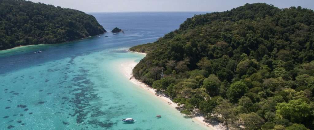
Day 2: Yacht Haven Marina (Phuket) – Nai Harn Bay (Phuket) – 37 nautical miles
Day 3: Nai Harn Bay (Phuket) – Ton Sai Bay (Phi Phi Don Island) – 28 nautical miles

Day 4: Phi Phi Don Island – Pan Lo Yai (Lanta Island) – 30 nautical miles
Day 5: Pan Lo Yai (Lanta Island) – Rok Islands – 25 nautical miles
Day 6: Rok Islands – Racha Island – 50 nautical miles
Day 7: Return to Yacht Haven Marina (Phuket) – 35 nautical miles
Detailed Itinerary
Arrival Day (Yacht Haven Marina)
Flights search
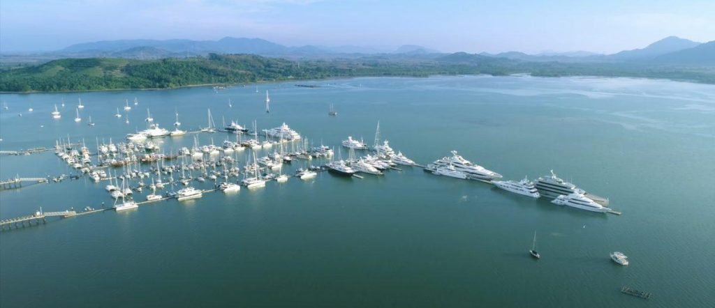
Your journey typically begins with a flight to Phuket International Airport, which is well-connected with many international and domestic flights. Most yacht routes in Thailand start from Yacht Haven Marina in Phuket. You can explore Phuket before embarking on your journey. The marina provides essential services, and it’s an excellent place to prepare for your adventure.
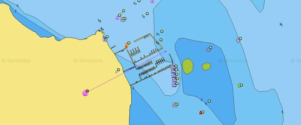
GPS: 08°10.241’N, 098°20.399’E
Phuket Yacht Haven Marina offers 320 berthing spots for yachts at its floating pontoons, accommodating vessels up to 100 meters in length. The marina features depths of up to 8 meters, making it suitable for a variety of yacht sizes.
The pontoons are well-maintained and regularly serviced, providing yachts with essential amenities like electricity, water, and access to Wi-Fi at each docking point.
Although the marina itself doesn’t have a grocery store, it does house a small café where you can order food and drinks for delivery directly to your yacht. For more extensive shopping needs, you’ll need to travel into the town. Additionally, just 100 meters north along the coast from the marina, you’ll find the “Living Room seafood restaurant & bar,” offering a convenient dining option close to the marina.
Day 2 (Yacht Haven Marina – Nai Harn Bay)
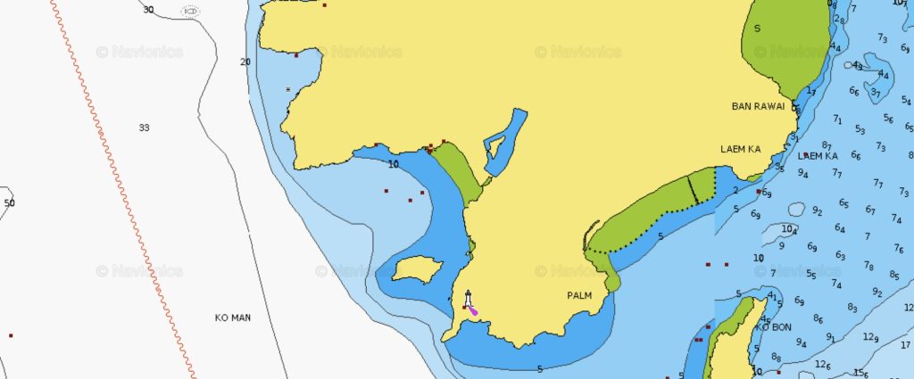
On the second day, you will sail along the eastern coast of Phuket from its northern tip (Yacht Haven Marina) to its southern end (Nai Harn Bay), covering a distance of 37 nautical miles. You will anchor for the night in this bay, amidst yachts moored in Nai Harn Bay in the south of Phuket. The yacht skipper needs to pay close attention to the very initial part of the journey – the exit from the marina, as there is a large shoal opposite the marina, the outlines of which are constantly changing. Usually, it’s possible to navigate between the shoal and the marina and then follow the navigational signs, but it’s advisable to confirm the passage of this section with the charter company where you rent the yacht. No further navigational problems are expected, but your yacht’s route will pass between many large and small islands, often at shallow depths, so it’s crucial to have a very clear understanding of the yacht’s current position throughout the journey.
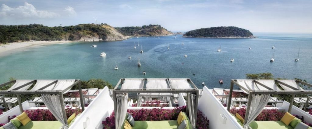
Yacht Anchorage in Nai Harn Bay
GPS: 07°46.341’N, 098°18.005’E
Yachts can anchor throughout the bay in depths of 8-10 meters. The bottom is sandy, providing good anchor hold. Yachtsmen should be aware that the bay is open to south-western winds.
There are several restaurants along the shore. The center of Phuket city is a 40-50 minute tuk-tuk ride away.
Nai Harn is a popular anchorage, including among those heading to the Similan Islands.
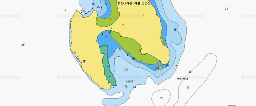
Day 3 (Nai Harn – Ton Sai Bay)
On this leg of your voyage, you’ll be heading east for about 28 nautical miles. The journey starts from Ton Sai Bay and takes you through a route interspersed with several small islands such as Koh Kaeo Yai, Koh Bon, Koh Hai, Koh Lon, and Koh Ne, lying off the coast of Phuket. This area is quite bustling with sea traffic, including numerous tourist yachts and swift tour boats, and you’ll find that local skippers often have a casual approach to maritime rules and may not readily yield.
This region is also a busy fishing ground, particularly for squid and fish. Fishermen in these waters commonly use nets and traps, which are usually marked by flags. While these fishing implements are typically set at depths that don’t pose a threat to yachts, there are occasional exceptions. To avoid any entanglement with these nets, especially if you suspect they might snag your yacht’s keel or propeller, it’s wise to steer a path well away from the flags. In cases where passing between flags is unavoidable, try to navigate through the middle where the nets are likely to hang lower. It can be tricky to tell whether a flag is marking a net or a trap, so this is where a skipper’s experience and gut feeling come into play. Solo flags often signal traps, and it’s best to avoid these especially from the windward direction.
Regarding trawling, which is another fishing method used in this area, it’s conducted either by single boats or pairs moving side by side, dragging a net between them. The key to avoiding any issues here is simple: keep a good distance and don’t attempt to pass between trawling boats. Ideally, you should navigate around them, either from the front or the rear.
As you approach Ton Sai Bay, you’ll need to be aware of a shallow bank, about three meters deep, located east of Phi Phi Don’s southern tip. The safest approach is to navigate around this bank from the east side, keeping it on your yacht’s left.
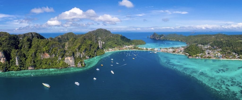
Yacht mooring on buoys in Ton Sai Bay
GPS: 07°43.512’N, 098°46.316’E
Ton Sai Bay is situated on the southeast of Phi Phi Don Island. Along its western coastline, numerous buoys have been installed for the use of yachts and local excursion boats.
It can be challenging to differentiate between private and guest buoys for yachts. A general indicator is that guest buoys are uniform in appearance and are plentiful, but this is not always a reliable sign. Occasionally, the owner of a buoy might ask you to vacate it. In such cases, you have the option to search for another available buoy or to anchor independently, which is also permitted. For shore access, you’ll use a dinghy, which can be left almost anywhere along the shore. Just be mindful of the tidal changes.
Ton Sai Bay is one of the few spots in the Phang Nga Bay where you can replenish your water supply by approaching the pier.
Day 4 (Phi Phi Don Island – Lanta Island)
On day four of your sailing adventure, you’ll set course for Pan Lo-Yai. This destination lies on the eastern shore of Lanta Island. Your journey for the day covers around 30 nautical miles along a straight course. Sailing from Phi Phi Don to Lanta’s southern edge should be smooth and unproblematic. Once past the cape, your route shifts northward. Along the way, keep an eye out for several movable sea farms to the east of your path. These farms can change locations, so it’s important for the skipper to visually monitor their positions, as they may not align with charted locations. As you navigate, you’ll pass Ko Po Island on your port side and proceed through the deepest waters of the strait that lies between Lanta’s eastern coastline and a string of smaller islets. Your anchoring point for the day is near Pan Lo-Yai’s lengthy pier.
Yacht Anchorage near Pan Lo-Yai on Lanta Island
GPS: 07°36.531’N, 099°08.050’E
The anchorage near Pan Lo-Yai, on the eastern coast of Lanta Island, offers a quiet retreat away from the bustling tourist spots of Thailand. It’s a location not frequently visited even by yachtsmen. A notable landmark here is the long pier along the shore. Anchoring in this area is reliable, with a depth of 3-4 meters in sandy terrain. The journey from the southern tip of Lanta to this spot is approximately 9 miles, passing through relatively shallow waters.
For shore excursions from the yacht, you can use a dinghy, which can be left at the end of the long pier. Onshore, there’s a charming, clean village featuring several stores, restaurants, and souvenir shops, providing a quaint and peaceful atmosphere for visitors.
Day 5 (Lanta Island – Rok Islands)
Your journey will next take you to the Rok Islands, nestled within a Marine National Park, a sail of about 25 nautical miles. Though it’s a shorter sail, it’s advisable to set off early to maximize your time at the Rok Islands. This area is renowned for its superb snorkeling conditions, offering a vibrant underwater world to explore. Additionally, the islands offer a unique experience onshore, where you can interact with the impressive two-meter-long lizards. Navigation-wise, this part of your trip is straightforward, without any particular challenges or dangers, provided the weather remains clear and calm.
Yacht Anchorages near the Rok Islands
GPS: 07°12.897’N, 099°03.859’E
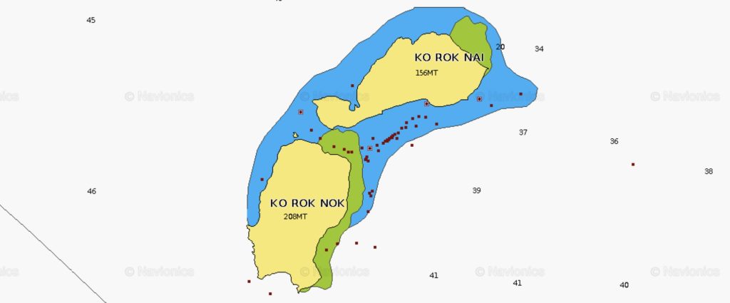
The Rok Islands, consisting of Ko Rok Nai and Ko Rok Nok, are located about 15 miles south of Lanta Island. Each island measures approximately 1 by 2 kilometers and they are separated by a strait about 250 meters wide.
Yachts can anchor either using buoys or their own anchors in depths of 5-10 meters over sandy bottoms. It’s important to be cautious and avoid anchoring on coral reefs to prevent damaging them or getting your anchor stuck.
The Rok Islands and their surrounding waters are part of the Mu Ko Lanta National Marine Park. The islands are renowned for their pristine beaches and coral gardens. They are covered in untouched jungles home to two-meter-long monitor lizards, hundreds of bird species, and small rodents. The islands are inhabited only by the rangers of the national park.
These islands are a favorite among yachtsmen for their excellent snorkeling and diving conditions, suitable even for beginners. The surrounding waters have no strong currents, are crystal clear, offer great visibility, and are relatively shallow. The marine life around the islands is rich, with tropical fish, hard corals in white and blue hues, sea anemones, and other marine fauna.
This makes the Rok Islands an ideal spot for those looking to explore underwater worlds in a serene and natural setting.
Day 6 (Rok Islands – Racha Island)
A longer sail of 50 nautical miles brings you to the Racha Island. As you head towards the Racha Island, your sailing approach will depend on the time of year. You might sail straight or need to tack back and forth. When picking a spot to anchor for the night around the Racha Island, it’s best to find a sheltered area on the side away from the wind, and you’ll find there are numerous choices for this. Navigation to the islands is pretty straightforward: just keep your yacht on a northwest course until the Racha Island are within sight. The only real concern during this part of your journey is the busy fishing activity in these waters, but as long as you’re mindful of this, your sail should be smooth.
Yacht Anchorage in Racha Yai Bay
GPS: 07°36.551’N, 098°21.766’E
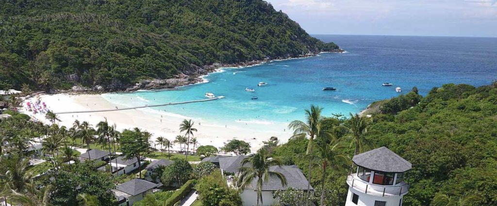
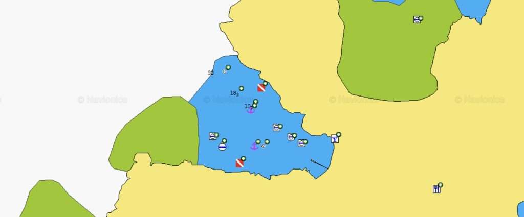
The anchorage at Racha Yai Bay is situated on the northwest side of the island. The ideal anchoring spots for yachts are found in depths of 10-15 meters on sandy bottoms. It’s advisable to anchor away from the inner bay, which has living coral reefs. There are sandy patches closer in, but skippers need to be cautious not to damage the reefs or get the anchor stuck. While there are buoys in the bay where yachts can moor, they are often occupied by local boats and their reliability can be questionable. The bay offers good protection from winds from all directions except the northwest.
Racha Yai Bay is a popular spot for its exceptional snorkeling opportunities near the reefs, attracting not just yachtsmen but also many tourists from Phuket who arrive on speedboats. Onshore, there are three small restaurants specializing in seafood, adding to the charm and convenience of this anchoring location.
Day 7 (Return to Yacht Haven Marina)
The return trip for your yacht involves sailing along Phuket Island’s eastern shore, a journey of roughly 35 nautical miles back to Yacht Haven Marina in Phuket, Thailand. Since this route retraces your earlier path, it doesn’t require a detailed description. After completing this final leg, you’ll hand over the yacht to the rental company and then it’s time to head back home, possibly with thoughts of planning your next yachting expedition already beginning to form.
How much does a vacation on a charter yacht in Thailand cost?
Budget Overview for 8 Crew Members
When planning your yachting adventure in Thailand for a group of 8 people, here’s a breakdown of the approximate costs per person:
- Yacht Charter: €4,000 (€500 per person)
- Skipper Fees: €1,050 (€131.25 per person)
- Mooring Fees: Approx. €350 (€43.75 per person)
- Fuel: Approx. €150 (€18.75 per person)
- Additional Costs: €250 (€31.25 per person)
- Total Cost per Person: Approximately €725
This estimate excludes flight tickets, transfers, meals, and daily activities. However, it provides a good foundation for budgeting your journey.